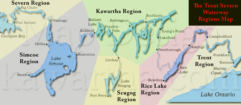
Central
Ontario encompasses
all six regions of Ontario's,
The Trent-Severn Waterway, offering a listing
service for residents
and tourists.
The
Trent Region starts at (1) Trenton on Lake Ontario and
ends at (13) Campbellford, other towns include Frankford, Belleville,
Brighton,
Picton and Bath..
The Rice Lake Region starts at (13) Campbellford
and ends at (19) Scott's Mill, other towns include Hastings,
Harwood
and Bewdley.
The Kawartha Region starts at (19) Scott's Mill
and ends at (36) Kirkfield, other towns include Peterborough,
Lakefield,
Young's Point, Burleigh
Falls, Buckhorn, Bobcageon and Fenelon Falls. Lakes include Katchawanooka,
Clear, Stony, Lovesick, Buckhorn, Pigeon, Chemong, Sturgeon,
Cameron and Balsam Lake.
The Scugog Region starts and ends at (33) Lindsay
allowing access to the Town of Port Perry and Lake Scugog.
The Simcoe Region starts
at (36) Kirkfield and ends at (42) Couchiching, other towns include Beaverton,
Barrie, Orillia, Washago and communities on the shores of Lake
Simcoe and Lake
Couchiching.
The Severn Region starts at (36) Couchiching
and ends at (45) Port Severn on Georgian Bay.
click
here for our COMPLETE LISTINGS
DETAILED
LOCK DESCRIPTION  <RETURN
TO PAGE TOP><VISIT
ALL OUR BUSINESS LISTINGS> <RETURN
TO PAGE TOP><VISIT
ALL OUR BUSINESS LISTINGS>
Lock
|
Station
|
Type
|
Chart
|
Lake
Ontario
KM - Miles
|
Region
|
GPS
(proximity)
| Lift
M - FT
|
| 1 |
Trenton |
Lock |
2021 |
0
- 0
|
Trent |
44.12071°N
- 77.59160°W
| 5.4
- 18 |
| 2 |
Sydney |
Lock |
2021 |
3.9
- 2.4
|
Trent |
44.13072°N
- 77.59152°W | 6.1
- 20 |
| 3 |
Glen Miller |
Lock |
2021 |
6.2
- 3.9
|
Trent |
44.15055°N
- 77.57970°W | 8.2
- 27 |
| 4 |
Batawa |
Lock |
2021 |
8.3
- 5.2
|
Trent |
44.16818°N
- 77.58638°W | 5.5
- 18 |
| 5 |
Trent |
Lock |
2021 |
10.3
- 6.4
|
Trent |
44.18484°N
- 77.59188°W | 5.5
- 18 |
| 6 |
Frankford |
Lock |
2021 |
11.7
- 7.3
|
Trent |
44.19776°N
- 77.59123°W | 4.9
-16 |
| 7 |
Glen Ross |
Lock |
2021 |
22.2
- 13.8
|
Trent |
44.26569°N
- 77.59697°W | 3.0
- 10 |
| 8 |
Percy
Reach |
Lock |
2021 |
40.7
- 25.3
|
Trent |
44.23592°N
- 77.78407°W | 6.0
- 20 |
| 9 |
Meyers |
Lock |
2021 |
42.5
- 26.4
|
Trent |
44.24690°N
- 77.80009°W | 4.9
- 16 |
| 10 |
Hauges
Reach |
Lock |
2021 |
45.0
- 28.0
|
Trent |
44.26730°N
- 77.79337°W | 7.3
- 24 |
| 11/12 |
Ranney
Falls |
Flight
Lock |
2021 |
47.8
- 29.7
|
Trent |
44.29031°N
- 77.80160°W | 14.6
- 48 |
| 13 |
Campbellford |
Lock |
2021 |
51.8
- 32.2
|
Trent
/Rice Lake |
44.31979°N
- 77.78615°W | 7.0
- 23 |
| 14 |
Crowe
Bay |
Lock |
2021 |
54.2
- 33.7
|
Rice Lake |
44.33516°N
- 77.77303°W | 7.6
- 25 |
| 15 |
Healy
Falls |
Lock |
2021 |
58.2
- 36.2
|
Rice Lake |
44.36891°N
- 77.77434°W | 6.6
- 22 |
| 16/17 |
Healy
Falls |
Flight
Lock |
2021 |
58.8
- 36.5
|
Rice Lake |
44.37283°N
- 77.77988°W | 7.3
- 24 |
| 18 |
Hastings |
Lock |
2022 |
82.3
- 51.1
|
Rice Lake |
44.30865°N
- 77.95703°W | 2.7
- 9 |
| 19 |
Scott's
Mill |
Lock |
2022 |
142.8
- 88.7
|
Rice
Lake /Kawartha
|
44.28926°N
- 78.30814°W | 2.4
- 8 |
| 20 |
Ashburnham |
Lock |
2023 |
144.5
- 89.5
|
Kawartha |
44.29924°N
- 78.30441°W | 3.7
- 12 |
| 21 |
Peterborough |
Lift
Lock |
2023 |
145.0
- 90.1
|
Kawartha |
44.30763°N
- 78.30098°W | 19.8
- 65 |
| 22 |
Nassau
Mills |
Lock |
2023 |
151.7
- 94.3
|
Kawartha |
44.36464°N
- 78.29033°W | 4.3
- 14 |
| 23 |
Otonabee |
Lock |
2023 |
152.6
- 94.8
|
Kawartha |
44.37248°N
- 78.28864°W | 3.7
- 12 |
| 24 |
Douro |
Lock |
2023 |
155.1
- 96.4
|
Kawartha |
44.38872°N
- 78.26960°W | 3.7
- 12 |
| 25 |
Sawer
Creek |
Lock |
2023 |
156.6
- 97.3
|
Kawartha |
44.40017°N
- 78.26287°W | 3.0
- 10 |
| 26 |
Lakefield |
Lock |
2023 |
158.9
- 98.7
|
Kawartha |
44.42001°N
- 78.27093°W | 4.8
- 16 |
| 27 |
Young's
Point |
Lock |
2023 |
168.1
- 104.5
|
Kawartha |
44.48823°N
- 78.23302°W | 2.2
- 7 |
| 28 |
Burleigh
Falls |
Lock |
2023 |
181.8
- 113.0
|
Kawartha |
44.55972°N
- 78.20815°W | 7.3
- 24 |
| 30 |
Lovesick |
Lock |
2023 |
18.7
- 114.8
|
Kawartha |
44.56196°N
- 78.25072°W | 1.1
- 3.5 |
| 31 |
Buckhorn |
Lock |
2023 |
194.2
- 120.7
|
Kawartha |
44.55558°N
- 78.34607°W | 3.5
- 11.5 |
| 32 |
Bobcageon |
Lock |
2025 |
222.4
- 138.2
|
Kawartha |
44.53906°N
- 78.54654°W | 1.6
- 5 |
- |
Port
Perry |
- |
2026 |
294.5
- 183.3 |
Scugog |
44.0905°N
-
78.9479°W
| - |
33 |
Lindsay |
Lock |
2026 |
251.6
- 156.3 |
Scugog |
44.35684°N
- 78.73527°W
| 2.1
- 7 |
| 34 |
Fenelon
Falls |
Lock |
2025 |
247.2
- 153.6
|
Kawartha |
44.53591°N
- 78.73718°W | 7.2
- 24 |
| 35 |
Rosedale |
Lock |
2025 |
252.9
- 157.2
|
Kawartha |
44.57171°N
- 78.77842°W | 1.2
- 4 |
| 36 |
Kirkfield |
Lift
Lock |
2025 |
272.6
- 169.4
|
Kawartha
/Simcoe |
44.58956°N
- 78.98955°W | 14.9
- 49 |
| 37 |
Bolsover |
Lock |
2025 |
284.9
- 177.0
|
Simcoe |
44.53457°N
- 79.07110°W | 6.6
- 22 |
| 38 |
Talbot |
Lock |
2025 |
286.5
- 178.1
|
Simcoe |
44.50959°N
- 79.10661°W | 4.3
- 14 |
| 39 |
Portage |
Lock |
2025 |
289.1
- 179.6
|
Simcoe |
44.50276°N
- 79.12626°W | 4.0
- 13 |
| 40 |
Thorah |
Lock |
2025 |
289.8
- 180.1
|
Simcoe |
44.49881°N
- 79.13262°W | 4.3
- 14 |
| 41 |
Gamebridge |
Lock |
2025 |
290.9
- 180.7
|
Simcoe |
44.48667"N
- 79.14889"W | 3.0
- 10 |
| 42 |
Couchiching |
Lock |
2028 |
337.8
- 209.9
|
Simcoe
/Severn |
44.76953°N
- 79.35024°W | 6.2
- 20 |
| 43 |
Swift
Rapids |
Lock |
2029 |
361.2
- 224.5
|
Severn |
44.85772°N
- 79.54036°W | 14.3
- 47 |
| 44 |
Big
Chute |
Marine
Railway |
2029 |
374.1
- 232.5
|
Severn |
44.88501°N
- 79.67474°W | 17.7
- 58 |
| 45 |
Port
Severn |
Lock |
2029 |
387.1
- 240.6
|
Severn |
44.80354°N
- 79.72033°W | 3.7
- 12 |
Please contact
us if you see an error or a problem. <RETURN
TO PAGE TOP><VISIT
ALL OUR BUSINESS LISTINGS>
|
|
Please
contact us if you see an error or a problem.
We
use 387 km
instead of 386 km because that is what we get
things to add up to.
Balsam Lake is the highest point in the system, not
Rosedale or Kirkfield. Kirkfield is 14.9 m below Balsam and
Rosedale is 1.2 m below.
The Kirkfield Lift Lock Chambers rise to
one foot below Balsam Lake, the system works when Balsam fills this
area in the chamber increasing
the weight, allowing it to descend so the opposite
chamber to can rise. The chamber coming down must always have more
water (weight) for the design
to function.
There is no lock 29 as two locks were replaced by one at Burleigh
Falls.
Purdey's Mills aka Lindsay aka City
of Kawartha Lakes, is a side branch
of The Trent-Severn Waterway accessing Lake
Scugog.
Brief
History of The Trent-Severn Waterway
The
start to finish time line spans eighty-seven years with the systems
construction starting in 1833 at Bobcaygeon and finishing in 1920
at Port Severn, three hundred and eighty-seven kilometers from
Lake Ontario.
A
feat of "Engineering and Perseverance" that is hard
to imagine when considering the construction techniques that
were available at the time.
The Navigation channel
runs a depth of six feet from start to finish. The locks vary
in raising the water level some exceptions are; flight locks,
the Big Chute Marine Railway with a lift of eighteen meters (58
feet), the Kirkfield Lift Lock with an average lift of fifteen
meters (49 feet) )and the Peterborough Lift Lock (finished in
1904) with an average lift of twenty meters (65 feet).
Peaking at Balsam Lake the system takes the traveler 180 meters (600
feet) above Lake Ontario and 80 meters (250 feet) above Lake Huron’s,
Georgian Bay.
Standard lock dimensions are one hundred and twenty feet long by thirty-two
feet wide. The two exceptions are the lock 44, the Big Chute Marine Railway
at one hundred feet long by twenty-four feet wide and lock 45 at Port
Severn is only eight-four feet long and twenty-three feet wide setting
the limit if you wish to traverse The Trent Severn Waterway from one
end to the other.
Two major upgrades were at Big Chute in 1960 and combining two locks
at Burleigh Falls in 1968 eliminating lock 29.
Please
Note: All dimensions are rounded hence approximate.
|
HELP SECTION<RETURN
TO PAGE TOP><VISIT
ALL OUR BUSINESS LISTINGS>
General:
-
The system is quite straight forward.
If you wish to see the details on various locks,
those are below, plus on our home page. We have
tried to establish the Regions from a logical
perspective and hope these are easy for you to
understand from the map we have provided..
- You don't need an account to browse, simply click
the Complete Listings button above.
- Post an ad, simply follow the path, region and
category see next door >>>.
- Place your listings in the appropriate category
when finished you'll be taken to the check out.
- The listings include, 10,000 characters (about
2,000 words), a google map if you choose to fill in your exact
location, our (your) URL's are SEO friendly so within a very short
time you will show up on search engines.
- We recommend you search using
the nearest lock and/or nearest town in the appropriate
category, nothing will get you closer to what you
are looking for.
- With 30,000 viewers and growing,
can you really afford not to have a Listing.
- Banner ads are available for all pages
or targeted to category pages. Pricing is available here. |
Listing
is Simple:
- Create an account
- Use your new ID and Password to Login
- Answer all the questions that apply to you
- Move to check out and your New Listing is Running
- Pricing is competative, create your own price.
- Unlimited Photos available
- Title bolding, better placement or featured property
- All listings contain a google map to your property
|
Editing
ads:
- Login to your account
- Select the "List" tab up top
- Under "My Account" choose "my active listings"
- Select "Manage This Listing" underneath the listing
- Select the little graphic "Pad and Pencil"
- Proceed with what you wish to edit |
|
<RETURN
TO PAGE TOP><VISIT
ALL OUR BUSINESS LISTINGS>
The Trent-Severn Waterway is part of Parks Canada!
This site is part of TheTrentSevernWaterway.com and is NOT Parks Canada
|